


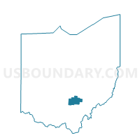
PRECINCT LAURELVILLE, Hocking County, Ohio
About
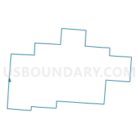
Outline

Summary
| Unique Area Identifier | 647963 |
| Name | PRECINCT LAURELVILLE |
| County | Hocking County |
| State | Ohio |
| Area (square miles) | 0.21 |
| Land Area (square miles) | 0.21 |
| Water Area (square miles) | 0.00 |
| % of Land Area | 99.03 |
| % of Water Area | 0.97 |
| Latitude of the Internal Point | 39.47388620 |
| Longtitude of the Internal Point | -82.73639130 |
Maps

Graphs
Select a template below for downloading or customizing gragh for PRECINCT LAURELVILLE, Hocking County, Ohio


Neighbors
Neighoring Voting District (by Name) Neighboring Voting District on the Map
- COLERAIN ADELPHI Voting District, Ross County, OH
- PRECINCT PERRY 1, Hocking County, OH
- PRECINCT SALTCREEK, Hocking County, OH
- Precinct SALTCREEK-SOUTH, Pickaway County, OH
Top 10 Neighboring County Subdivision (by Population) Neighboring County Subdivision on the Map
- Saltcreek township, Pickaway County, OH (2,925)
- Perry township, Hocking County, OH (2,560)
- Colerain township, Ross County, OH (2,148)
- Salt Creek township, Hocking County, OH (1,210)
Top 10 Neighboring Place (by Population) Neighboring Place on the Map
Top 10 Neighboring Unified School District (by Population) Neighboring Unified School District on the Map
Top 10 Neighboring State Legislative District Lower Chamber (by Population) Neighboring State Legislative District Lower Chamber on the Map
Top 10 Neighboring State Legislative District Upper Chamber (by Population) Neighboring State Legislative District Upper Chamber on the Map
Top 10 Neighboring 111th Congressional District (by Population) Neighboring 111th Congressional District on the Map
Top 10 Neighboring Census Tract (by Population) Neighboring Census Tract on the Map
- Census Tract 9555, Ross County, OH (6,002)
- Census Tract 217, Pickaway County, OH (4,966)
- Census Tract 9650, Hocking County, OH (3,879)